Georgia knew it had a problem with broadband. But it didn’t know the depth of its problem. It didn’t know exactly where the problem was or exactly who faced it.
To solve this problem, the Georgia Broadband Program turned to the Carl Vinson Institute of Government at the University of Georgia to create a map showing precisely which Georgia homes and businesses were served and not served by high-speed internet service. It was to develop methodology for more accurately defining an area or locations as served and then present that in visual form.
Leaders realized they could not solve broadband access problems in Georgia without better information. Before they could work to bring in more robust access, they had to know where it was needed – and by whom.
The Georgia Broadband Program turned to the Carl Vinson Institute of Government at the University of Georgia, which immediately recognized the need for new methodology.
The Institute team saw that Federal Communication Commission (FCC) maps had the potential to ignore a great many locations – leaving many, many Georgians out of line for access.
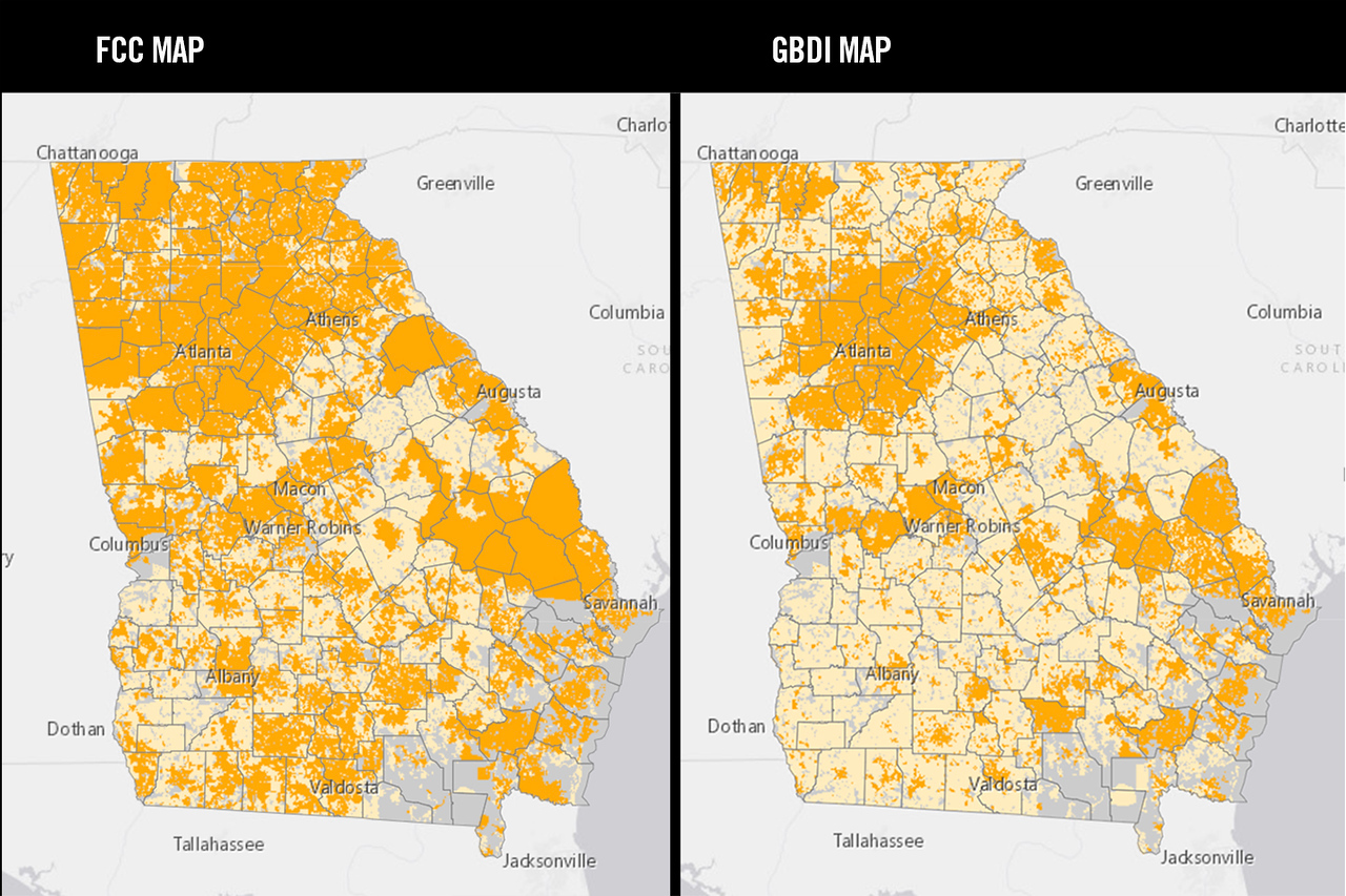
For the map, the Institute of Government developed a new methodology to define “served” and “unserved.” This methodology more accurately depicted the availability – and lack – of broadband in Georgia. While the FCC had marked blocks as served if any one location in the block was served, the university felt a more accurate measure would be the rate of locations in a block, which it defined as “served” only if 80 percent or more of locations within had access.
Information was gathered for each business and residential address in the state and internet service providers were asked to share where they provided broadband. The location data was then laid against the service data and displayed in an easy-to-understand, interactive online map.
For location data, the Institute of Government leaned on commercially available information (Digital Map Products datasets), county tax appraiser parcel data, United States Postal Service address data, Microsoft building rooftop data and electricity meter location information. It integrated these datasets to produce the most precise location information possible, down to coordinates for latitude and longitude.
The team coordinated service data from 44 internet service providers, checking it against the state’s master address file and returning to providers for correction and confirmation before compilation.
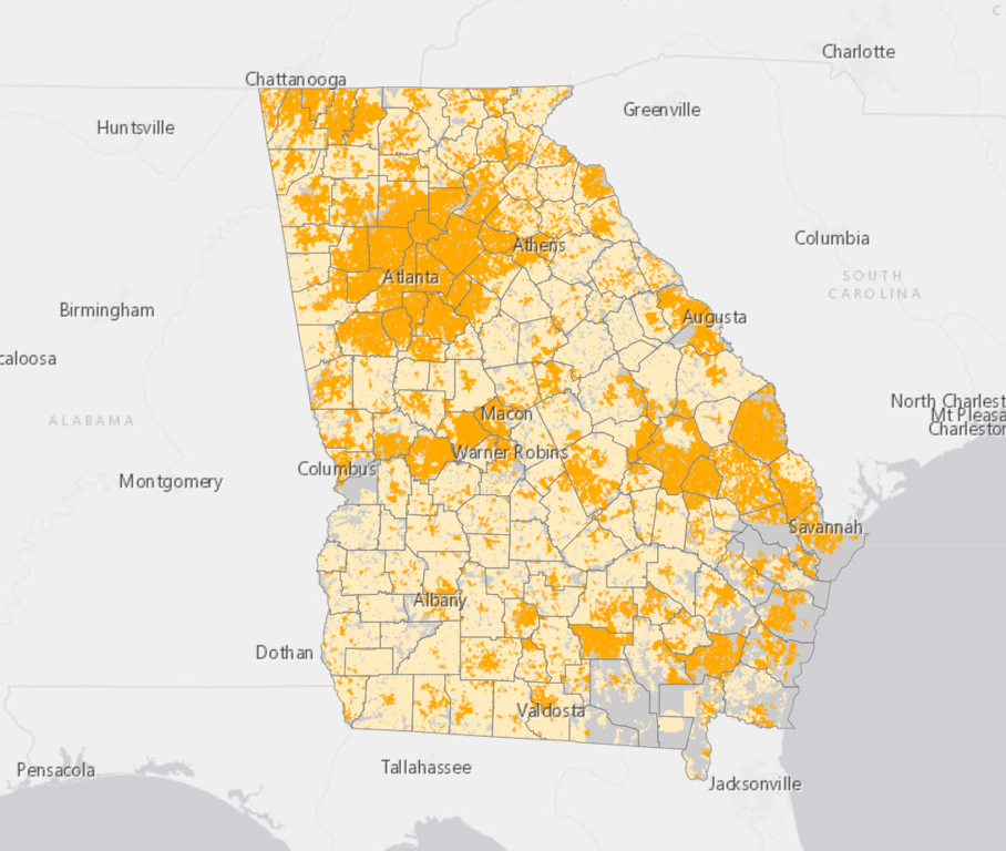
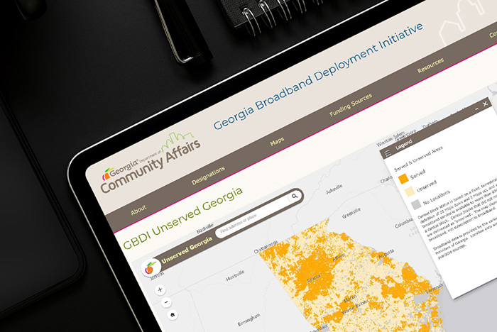
The Institute of Government then used the latest mapping tools to create the views of broadband access that today appear on the Georgia Broadband Program website, https://broadband.georgia.gov/.
When it debuted in June 2020, the map set a new gold standard in broadband access mapping and made Georgia the first state to map availability down to the street address level. The Georgia Broadband Map was the first of its kind in the United States. It accurately tracks broadband dead zones down to a single address.
Unlike the FCC map – which considers a census block served by high-speed internet if just a single home in that block is connected – UGA’s map has a threshold of 80 percent of homes in a census block connected to speeds of 25 megabytes per second (Mbps) download and 3 Mbps upload.
The more precise method of mapping identified more than half a million locations that lacked broadband availability. More than half – 255,067 locations - had previously been identified as served.
When it launched in 2020, the map plainly illustrated a stark truth: About 10 percent of the Georgia population lacked access to high speed internet. That’s several percentage points higher than the FCC maps had suggested. And, while 10 percent might seem small, that’s actually more than 1 million people without service.
The more precise map means more communities will be able to apply for needed funds – both public and private - to develop broadband. It also enables state leaders to more confidently allocate resources for broadband, including a Georgia General Assembly commitment of $30 million.
The Georgia Broadband Map offers multiple views, including areas of the state color coded for served or unserved by broadband, a county view and a side-by-side comparison of the FCC map versus the Georgia map.
Numerous entities were involved in the map’s development and deployment. Governance is coordinated by an inter-agency team comprised of
Outreach has capitalized on workshops and webinars with community groups as well as partnerships with the Georgia Municipal Association and Association County Commissioners of Georgia.
Near the Alabama border, the west Georgia counties of Heard, Haralson and Carroll look forward to an expansion of fiber-to-the-home service reaching an additional 10,000 homes and 30,000 Georgians.
The north Georgia counties of Cherokee, Dawson, Lumpkin and Pickens anticipate a project that will bring 250 miles of fiber, extending access to 6,000 customers.
Three sizeable projects announced in the first few months of 2021 promise broadband service expansion in some 20 middle Georgia counties combined. These efforts stand to extend high-speed (fiber) internet service to 12,000, 22,000 and 80,000 homes and businesses per project.
During the COVID-19 pandemic, a special-purpose map was published on the Georgia broadband website using data collected through the broadband map project. It showed locations statewide where students could find free public Wi-Fi access. That service often would be outside then-closed public buildings (e.g., libraries, schools), with people connecting from cars parked near those facilities.
Visit the Georgia Broadband Program website at https://broadband.georgia.gov/.
 |
|
|
University of Georgia Broadband map helps state pinpoint areas in need Nearly a year after unveiling a groundbreaking map that showed far more Georgians than previously thought were without broadband access, the University of Georgia has helped the state distribute more than $400 million in grants to bring faster and more reliable internet service to communities throughout the state. |
|
 |
|
|
Georgia Broadband Map recognized by state Chief Information Officers group The National Association of State Chief Information Officers (NASCIO) named the Georgia Broadband map as a finalist for the State IT Recognition Awards while also referencing the importance of broadband mapping projects like ours. |
|
 |
|
|
Georgia Broadband Map first in nation to show individual unserved locations This latest update pinpoints actual unserved locations. |
|
 |
|
|
Georgia’s Broadband Map gets marked update, shows continued lack of access The Georgia Broadband Program recently launched an updated Georgia Broadband Availability Map. |
|
 |
|
|
McRae continues presentations and workshops for broadband opportunities Eric McRae, associate director for Information Technology Outreach Services at the Institute of Government, continues to promote and educate the public and providers on Georgia’s broadband mapping project. |
|
 |
|
|
Revolutionary map expanding statewide internet access for Georgians Thanks to a groundbreaking map — the first of its kind in the United States — community leaders and telecommunications companies in Georgia can now easily identify broadband dead zones down to a single address and expand access to those areas. |
|
 |
|
|
Institute helps develop key tools for Georgia’s broadband mapping project Georgia’s new interactive maps of broadband internet availability utilize online tools the Institute of Government developed with state agencies and private service providers. |
|